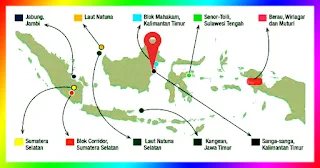
After completing Leg-2, the Public Service Agency (BLU) Center for Marine Geology Research and Development, the ESDM Research and Development Agency together with PT Pertamina EP completed the Geothermal Microseapage Area Offshore Leg-3 Survey on Matindok Block, Central Sulawesi on 20 December 2019. Geomarin III Research Vessel (KR Geomarin III) has arrived back at the Port of Cirebon on December 26, 2019.
Geomarin III Research Vessel (KR Geomarin III)
Previously the Head of Research and Development Agency of the Ministry of Energy and Mineral Resources Dadan Kusdiana mentioned, the survey was conducted to increase the potential of oil and gas reserves, in order to ensure the sustainability of the upstream oil and gas industry. One of the great potentials is the potential of oil and gas resources in the Matindok offshore area, which includes the prospect area of Bubalus, Kudu-kudu, and Kepe-kepe.
"This activity is also intended to anticipate the high risk of drilling and high costs, related to the alleged existence of potential hydrocarbons in the Matindok Beach area and reduce the risk of operational drilling in the deep sea," Dadan was quoted as saying www. esdm.go.id.
The Geomarin III Research Vessel departs from the Port of Bitung towards the first Leg 3 coring survey location in Matindok Waters, Luwuk, Central Sulawesi since 9 December 2019. Before starting Leg-3, BLU P3GL together with PT Pertamina EP held a Management Walk Through (MWT) for activities Matindok Geochemical survey, in Bitung North Sulawesi on 8-9 December 2019.
For 15 days, the team cored 79 microseepage samples and coreded two drilling wells with 20 samples. Previously, the team conducted a geophysical survey on 26 October to 7 November 2019, while the geological survey began on 13 November until the end of December 2019. The Center for Marine Geology Research and Development carried out all survey activities for three months, from preparation, acquisition of geophysical data and sampling for geochemical analysis.
Data acquisition activities have begun in mid-October to the end of December 2019. Microseepage targets for all of these activities include 180 locations, macroseepage covering 20 locations and well calibration as many as 30 locations. Leg-2 successfully completed 121 points, consisting of 101 microseepage locations and 20 macroseepages and 10 well calibration locations.
P3GL conducted a survey on an area of 1,225 km2 with an average water depth above 500 meters to 1,000 meters. The survey vehicle used in this study was KR Geomarin III and supported by geological and geophysical survey equipment, including Multibeam Echosounder (MBES), Subbuttom Profiling (SBP), Sidescan Sonar (SSS), and Piston Corer equipment, and equipped with Sound Velocity Profile (SVP).
In general, the Donggi-Matindok oil and gas field has an important role in supporting the production of Indonesia's liquefied natural gas (LNG). PT Pertamina EP Asset 4 has developed the Donggi Matindok Field oil and gas field since April 2016.
IN INDONESIA
PSGL dan Pertamina EP Selesaikan Survei di Blok Matindok
Setelah menyelesaikan Leg-2, Badan Layanan Umum (BLU) Pusat Penelitian dan Pengembangan Geologi Kelautan, Badan Litbang ESDM bersama PT Pertamina EP menyelesaikan Survei Geokimia Microseapage Area Offshore Leg-3 di Blok Matindok, Sulawesi Tengah pada 20 Desember 2019. Kapal Riset Geomarin III (KR Geomarin III) telah tiba kembali di Pelabuhan Cirebon pada tanggal 26 Desember 2019.
Sebelumnya Kepala Badan Litbang Kementerian ESDM Dadan Kusdiana menyebut, survei dilakukan untuk meningkatkan potensi cadangan minyak dan gas, demi menjamin keberlangsungan industri hulu migas. Salah satu potensi yang besar adalah potensi sumber daya migas di area lepas pantai Matindok, yang meliputi area prospek Bubalus, Kudu-kudu dan Kepe-kepe.
“Kegiatan ini juga dimaksudkan untuk mengantisipasi tingginya risiko pengeboran dan biaya tinggi, terkait dugaan keberadaan potensi hidrokarbon di area Pantai Matindok serta mengurangi resiko operasional pemboran di laut dalam,” ungkap Dadan seperti dikutip www. esdm.go.id.
Kapal Riset Geomarin III bertolak dari Pelabuhan Bitung menuju lokasi survei coring pertama Leg 3 di Perairan Matindok, Luwuk, Sulawesi Tengah sejak tanggal 9 Desember 2019. Sebelum memulai Leg-3, BLU P3GL bersama PT Pertamina EP menggelar Management Walk Through (MWT) untuk kegiatan survei Geokimia Matindok, di Bitung Sulawesi Utara pada tanggal 8-9 Desember 2019.
Selama 15 hari, tim melakukan coring 79 sampel microseepage dan melakukan coring kalibrasi dua sumur pemboran dengan jumlah sampel 20 buah. Sebelumnya tim telah melaksanakan survei geofisika pada tanggal 26 Oktober hingga tanggal 7 November 2019, sedangkan survei geologi mulai dilaksanakan tanggal 13 November hingga akhir bulan Desember 2019 Pusat Penelitian dan Pengembangan Geologi Kelautan melaksanakan seluruh kegiatan survei selama tiga bulan, mulai dari persiapan, akuisisi data geofisika dan pengambilan sampel untuk analisis geokimia.
Kegiatan akuisisi data telah dimulai pertengahan bulan Oktober hingga akhir bulan Desember 2019. Target microseepage pada seluruh kegiatan ini meliputi 180 lokasi, macroseepage meliputi 20 lokasi dan kalibrasi sumur sebanyak 30 lokasi. Leg-2 berhasil menyelesaikan 121 titik, yang terdiri dari 101 lokasi microseepage dan 20 macroseepage dan 10 lokasi kalibrasi sumur.
P3GL melakukan survei pada area seluas 1.225 km2 dengan kedalaman air rata-rata di atas 500 meter hingga 1.000 meter. Wahana survei yang dipergunakan dalam penelitian ini adalah KR Geomarin III dan ditunjang peralatan survey geologi dan geofisika, di antaranya Multibeam Echosounder (MBES), Subbuttom Profiling (SBP), Sidescan Sonar (SSS), serta peralatan Piston Corer, dan dilengkapi dengan Sound Velocity Profile (SVP).
Secara umum, Lapangan migas Donggi-Matindok memiliki berperan penting dalam mendukung produksi gas alam cair atau Liquefied Natural Gas (LNG) Indonesia. PT Pertamina EP Asset 4 mengembangkan lapangan migas Donggi Matindok Field sejak April 2016 lalu.
Investor Daily, Page-14, Saturday, Dec 28, 2019


